Sunday, May 13, 2012

Day 17: Bryce Canyon, or, things start to go south

Seeing as how we had some extra time that would otherwise have been wasted driving across Nevada on deadly-boring I-80, Alex and I remapped our trip to include a dip across part of the American southwest--Bryce, Zion, Las Vegas, LA, and, via HW 1, SF. If we stick to our plan, we'll arrive in SF on May 14th, exactly the latest we can possibly arrive. If we run into any problems, we have a couple of options for saving a day or two (e.g. skipping a night in Vegas). With this new plan, we spent today in Bryce Canyon National Park and then drove over to Zion. 

If the Badlands are a moonscape, Bryce is a terraformed version of Mars. Everything is red, red, red, dry and dusty. The vistas from the overlooks are jaw-dropping:

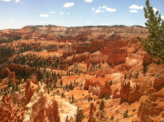


The most interesting features of Bryce are the hoodoos, windows, spires and other erosion features lining the canyon. Let's take a look at them!

Here's a hoodoo:


A hoodoo is a particular columnar rock formed not by running water erosion but by ice erosion. What happens is that the limestone has microfractures (often caused when impurities such as clay create plans of weakness that then are expressed by thermal fracturing) that fill with water. Bryce is quite high up, so the water turns to ice at night, forcing the microfracture further apart, eventually carving off a shaving of rock. Over time this splits walls of stone into the individual columns known as hoodoos, and later it eventually turns those hoodoos into dust. The top of the hoodoo is often made of material more resistant to erosion than the material below it--this is, apparently, one reason the hoodoo formed where it did, because the cap protected the softer stone below it.


By the way, don't hoodoos kind of look like people? The Paiute people thought so too, and incorporated that into their mythology. Personally, I don't think it's true.

Here's a picture of a window:


In Bryce, I'm pretty sure that this forms because the stone above and below the window is more resistant to erosion than the stone that was removed, although as we learned in the ranger evening program tonight at Zion, windows and arches can also form when water seeps through the limestone and reaches harder rock, such as shale, that is not permeable to water, and the water then erodes the base of the rock, causing it to fall away and reveal a window or arch. (This same presentation involved a multi-minute music-backed slideshow of arches. People are really into their arches. There's even a society: http://www.naturalarches.org/ This society hired climbers to settle "open" (haha) issues such as the pressing question of which arch is the biggest.)

A spire is a place where the hoodoo cap has been eroded away and the hoodoo is beginning to erode itself: 


Finally, here's a really sweet looking hoodoo called Thor's Hammer that we saw when we descended a trail into the canyon:


Isn't that awesome? Yeah, I thought so too.

Oh, one more thing: it turns out that Bryce Canyon isn't a canyon, as we learned in today's ranger talk on geology (led by an awesome ranger who has an equally awesome url: http://www.iamthedarkranger.com). Apparently canyons are formed by rivers and, as you learned earlier, Bryce canyon is all about snow and ice erosion. Apparently when you tell the Zion rangers that you're going to Bryce Canyon, they scoff and say, "it isn't even a canyon!" Now you know!

Bryce (not-really-a) Canyon is also probably the highest we've been on the trip, with an elevation over 8000 feet (high enough to cause altitude sickness if you went straight up). For us, though, it was only a couple thousand feet higher than previous locations--much of Yellowstone is between 6000 and 8000 feet. From some overlooks (which we didn't go to), you can reach 9000 feet and see over 110 miles on a clear day. How's that for a great view?

Bryce isn't a huge park, and we didn't feel the need to explore the farthest recesses just to see what it's like to look 100 miles (given that we just looked millions of miles in the night sky program the day before), so we headed over to Zion National Park.

Wow!!

There are two striking things about Zion.

The first is that its landscape is even more badass than Bryce, with what can only be described as giant mountain fortresses:


Apparently these fortresses are the result of litholized sand dunes (as we've learned on this trip, the rocky mountains used to be a sea; but before they were a sea, they were a desert. Isn't geology great?) that got extruded as part of some complicated geologic process that involved magma. (As if that tells you anything. Heck, I might not even be right about that.)

Anyway, however they got here: wow, they are impressive.

The second striking thing is that Zion is in its high season right now and OMG there are lot of people here. It's actually kind of cool because there are ranger led activities all the time, and our experience so far has been that ranger led activities are pretty great. (It's kind of like going to camp, except without the awkwardness of having to shower with people you don't even know.)  Incidentally, there are also a lot of little kids at the ranger talks, since going to ranger talks is a requirement for getting your Junior Ranger badge.  (At the geology talk in Bryce, the ranger asked a little girl to write down something she learned from the talk, but it turned out she didn't know how to write yet.)  It also means that all of the hotels and restaurants are open--so instead of dead Gardiner, Montana we have lively Springdale, Utah, and the nicest (and, okay, most expensive) hotel room of our trip to boot.

A few more short notes on Zion--more tomorrow after we've experienced more of the park.

1) They have this huge--like 1 mile+ tunnel--that you use when coming from Bryce. It's built into this enormous rock face, and it's completely terrifying--one lane in each direction, totally dark, directly into a mountain, with no idea how long it will take when you first enter it.

2) Zion is way lower elevation that Bryce (about 4000 feet), and you can tell; it's much warmer. It also feels more lush; Bryce is totally arid, covered with bristlecone pines and sagebrush. Zion has its share of this stuff, but we saw some 'real' cactuses and what look to be green trees and grass.

Tomorrow we find out what Zion is really like!

Clarification

One question I get a lot about this blog is, who writes the posts?  I decided to make a little crib sheet that might clear things up for people:

Day 1: Alex
Day 2: Alex
Day 3: Alex
Day 4: Alex
Day 5: Alex
Day 6: Alex
Day 7: Alex
Day 8: Alex
Day 9: Alex
Day 10: Alex
Day 11: Alex
Day 12: Alex
Day 13: Alex
Day 14: Alex
Day 15: Alex
Day 16: Alex

In addition, I'll try to remember to sign the posts to help make it clearer in the future.

Hope that helps!

Alex

Friday, May 11, 2012

Day 16: Salt Lake City

We started the morning today by going back to Temple Square.  We were careful to avoid the visitors centers this time, but Alex wanted to see the roof of the conference center.  It is: a roof with plants on it.  Trees on one side, wild prairie flowers on the other.  And a couple of fountains.  AND the conference center contains upper tiers of seating for about ten thousand with no internal support beams.  Kind of amazing that the building doesn't collapse.


Since we were parked right next to it, we also popped in to the LDS history and art museum.  The art is super tacky with a big emphasis on all the cultures of the world, which I felt kind of ironic since the church didn't allow Blacks to fully participate in the sacraments until 1978.  But not as ironic as the big sampler from South Africa that read "The Mormon Creed Is To Mind Your Own Business".  I guess the folks working in the visitors center haven't gotten around to seeing the museum yet.  There was also some children's drawings in the basement, which was actually my favorite part of the art display:


The history section was a lot more interesting.  I learned that Mormons lived in co-ops with Utopian names like Orderville (seriously, we even drove through it a few days later) that printed their own money since they were short on actual cash.  It looked like every single dollar bill was signed by Brigham Young.


We also watched a video about a woman (Jane Rio Baker, if you want to Google her) who traveled from London to Utah in the 19th century to join the church.  I thought it was interesting to hear the details of what it took to get that far, and her journal excerpts were quite good.  Alex thought it made her look kind of crazy, but even though it took her 9 months she was happy in the end because only one of her family members died along the way.  After wrapping up the section on 19th century pioneer life, we skipped the bit on every leader of the church, and headed out to the Great Salt Lake.

The Great Salt Lake is amazing.  And terrible.  It is repulsive and fascinating all at once.  I knew from Tripadvisor to expect flies and a funny smell rather than a beautiful lakefront, but it didn't prepare me at all for what I saw.


First, there is mud.  When people walk in the mud they leave footprints that fill in with salt water that then slowly evaporates, so each footprint's muddy puddle has a thick layer of salt crusted on the surface, like ice on partially frozen water.  You can pick these sheets up and put them in the water and watch them (temporarily) melt.  There are crystaline ice formations that look like frost on a windowpane, small ones and huge ones alike.

And then there are the birds.  The beach is littered with hundreds of dead birds in various stages of skeletal-ness.  From my experience at Fossil Butte, I am pretty sure that a bunch of them are going to become very pretty fossils...you can see them half buried under the sand already, feathers intact.  There are so many that you have to watch carefully so you don't step on them.  According to news reports, there were big die-offs in 2008 and 2009, from avian cholera and botulism.

So the resulting experience is pretty amazing.  It's not pleasant at all, but it's totally fascinating.


Below: Dead bird


Also, next to the beach we were at, there was a concert venue (under construction) that for no apparent reason had a gift shop selling salt water taffy and stuff, and it was open.  It was your typical store that sells to tourists except I cannot imagine tourists going to the lake--at least that part--to buy taffy.  It was like if somebody were selling I Heart New Orleans keychains inside a condemned house in the remains of the Lower 9th Ward.

After leaving the lake and getting as much mud off of our shoes as possible, we hopped in the car and headed south along I-15 to Bryce Canyon.  We arrived in time to take in a ranger program at the park.  During the first part, a ranger gave a presentation on weather patterns of other planets in the solar system.  (He also reflected that working in Bryce was better than Yosemite because no visitors commit suicide in Bryce.)  It was a bit scary to see that (at least theoretically, although the temperature changes probably wouldn't be extreme enough in practice) global warming type effects could lead to a runaway reaction that could turn an Earth-like planet into a Venus-like planet.  We then got to see a number of planets and stars, including Venus, Mars, Saturn (the last under a telescope...it honestly looked like a stylized icon of Saturn), and a few galaxies (also with a telescope...the light was wrong for the Milky Way, unfortunately).

Thursday, May 10, 2012

Day 15: Fossils and Utah


Today we started out the morning by going to the National Wildlife Art Museum, on a hot tip from my mom.  First we made some wildlife art of our own by photographing the ground squirrels and marmots in the parking lot.  Ground squirrels are the little chipmunky ones, and marmots look like confused beavers who are hanging out in a parking lot instead of damming a river.


The museum is pretty cool--thanks, Ma!  It is an a beautiful building and is very well curated--for example, one of the exhibits was on different genres of depicting animals: as a heroic male, an object of hunters, an organic part of their environment, anthropomorphized, etc. with groups of paintings demonstrating each type of depiction.  We learned, for example, that many 19th century depictions emphasize how great hunting is in America, since in most of Europe commoners were not allowed to hunt, while in America it was not just a popular pasttime but a necessity.  Another exhibit talked about a guy who revolutionized taxidermy by using anatomically detailed wireframe sculptures of the animals as a basis.  My other favorite exhibits were a great explanation of each step of the lost wax casting process (including "sandblasting" which I'm pretty sure my art history textbook left out) and all the Wyoming entries for the national duck stamp competition.  There was some very cool contemporary art as well...I actually wish there had been more.


After Jackson, it was on to Utah!  We took a bit of a...detour down a bit of highway we never meant to be on and ended up following a turnoff for Fossil Butte National Monument, because why not?  It turned out to be an excellent decision.  Our path was immediately blocked by two men on horseback, six sheepdogs, and several hundred sheep being herded across the road.  It was awesome to watch and the dogs did a fantastic job.


When I got out of the car to take a picture, one of the dogs trotted over to me and started making funny noises...I think it was trying to get me back to the herd and was only satisfied when I got in the car and started driving toward the rest of the sheep.  This also helped answer the question, "what are they doing with all those horses we see grazing on the roadside? and later we also saw a farmer plowing (I think it was plowing, although why you'd need to plow a livestock field I don't know) a field of cattle using a horse-drawn plow...I guess it's less likely to spook the cows.

For those following along at home, the list of animals that have at some point blocked our way is now at:
1) Bison
2) Deer (briefly)
3) Sheep

Once the sheep were done we continued up the road to the national monument.  It turns out there isn't really much you can see of the monument itself at the moment, but they do have a fantastic visitors center.  Fossil butte used to be a lake millions of years ago, and there are, according to the rangers, several trillion fish fossils in it.  They've also found some rarer fossils, like two snakes, a primitive horse, and a couple of bats (one of which is currently at the Yale Peabody Museum, and the other of which was featured on the cover of Nature...you can read a summary of the article here but the summary of the summary is that the fossil supports the theory that bat-flight evolved before bat-echolocation).  They told us all about the procedure for finding fossils...apparently it's quite easy, as when you break open a rock with a fossil in it, it will tend to split open right where the fossil is, because the fossil creates structural weakness.  There are places you can even do this commercially and take your fossil home with you, although none were open when we went.  The next step is to dig the fossil out of the rock, using a tiny jackhammer-like tool.  This part can be done either super-carefully, like a scientist would do it, or commercial-grade, which takes about one twentieth the time.  Apparently most of the fossils are actually on privately owned land, and the landowners don't have any obligation to keep the fossils in perfect condition, or to preserve them at all, although the nicer fossils the private landowners find often end up sold to museums or corporations and dug out very carefully.  (A rare fossil like a snake will run a few hundred thousand dollars...a large group of aesthetically pleasing but common fossils (like fossils of a mass die-off of fish, often caused by changes in water temperature or chemistry) will be in the ten to twenty thousand range, and a dirt common small fossilized fish is about forty bucks.)  We learned that the kerogen shale containing the fossils could potentially be mined for oil, although none of the techniques available are sufficiently energy-efficient to make sense.  If you scratch the shale with your finger, it smells like natural gas.


Next, it was onward to Salt Lake City!  We got there in time to have dinner and pop in to the visitors center at the Temple Square--the center is very nice and impressive, especially if the word "tacky" isn't in your vocabulary.


The two missionaries at the visitors center somehow chose us to latch on to and it was just kind of painful.  They trailed us around the place and were so enthusiastic and apparently really thought that conversational gambits like, "who is your favorite prophet?" (waits for answer, does not care what answer is)  "there is always a prophet on earth.  The current one is Thomas Monson.  He gives us direction and helps tell us the Word so we will never be confused..." and then giving us a form to fill out us we could get a followup visit are actually successful ways of gathering converts.  It felt exactly like being followed off the T by some creepy guy trying to get my phone number...I'm guessing some missionaries are better at it than ours were.

The big focus in the visitors center is on Bible stories and "God likes strong healthy families"; the center is obviously trying very hard not to turn off mainstream Christian visitors.  There is a very noticeable lack of depictions of scenes from the Book of Mormon or anything else related to specifically Mormon theology--well, the "forever families" thing had a Mormon undercurrent, but it was easy not to notice if you didn't know it was there.  The other thing that was strange was walking down the street and hearing tourists flag down the Mormons walking down the street--"sisters!  Do you know if that building is open?"  However, I was surprised by how normal the rest of Salt Lake City, outside of the Temple Square, felt...there are breweries and restaurants that serve wine and all of that.

We also went across the street to the conference center, which seats 21,000 people.  A nice guy who worked there let us in and showed us about how the engineering works, what they use it for, the green roof, etc.  We will be back in the morning to check it out!

Wednesday, May 9, 2012

Day 14: Jackson, WY

This morning, we headed to Yellowstone to get some proper photos of Old Faithful.


Isn't that better?

Then we went to the Tetons!  They are very majestic.

Getting to the Tetons may have been my favorite part.  You go up and down these big rolling hills in Idaho at 60mph and it's like being on a rollercoaster except most rollercoasters don't have potato fields for scenery.  On the way, we passed towns with populations of 250 and whose major shops included Billy Joe's Taxidermy.  We also went to a supermarket to try to get Alex some cough medicine and drove by a woman riding a horse through the parking lot.  It was surreal.


Next you go up a winding road into the mountains, and then you go down a winding road.  The winding road down has a ton of signs like "Trucks: test brakes" and "Trucks: 10% grade" and "Trucks: Maybe you should just run around" (ok I made that one up).  There are also a few  "runaway truck ramps" which are just these big uphill ramps off the side of the road that you can drive your truck into if you lose control if it, and then you can cry, because there's really no way out of the runaway truck ramp that I can see, there isn't even room to turn your truck around.  (Hopefully your truck doesn't just roll right back down the ramp.)

But finally, all this takes you to Jackson, Wyoming!  Alex was pleasantly surprised by the $500/night hotels and $100/head restaurants in this town of 10,000 people and apparently had no idea that this was a ski resort town...fortunately May is not a big month for skiing so we were able to find a hotel that did not cost $500 a night.  We headed to Teton National Park and got good views of the mountains, Jenny Lake, the Snake River, etc. and I learned all about Beaver Dick Leigh who surveyed the Tetons and had a wife and six children who all died of smallpox.  We didn't see any elk because it was too warm (they like the mountains this time of year) but apparently they come out in force during the winter.


Oh, I almost forgot, this is what the city park entrances in Jackson look like (yes, those are real antlers, collected by Boy Scouts, apparently?)


At night, Alex wanted to see the stars, so we did!  It was a bit difficult to identify things, but we did spot Venus, which is apparently especially bright this time of year, and Alex enjoyed looking at stars with his binoculars.  I sometimes read in books about a full moon or a new moon and this having an effect on characters' traveling at night, and wondered, really?  Does the moon make that big of a difference?  Well, I can now tell you that the answer is absolutely yes.  The supermoon was out, and it was HUGE and ORANGE and incredibly bright, and even without much cloud cover, it ended up never getting truly dark...you could never not see the mountains, or your hand in front of your face, etc. even with no other light sources.

The phone didn't do a great job photographing it, but it does kind of give you the idea of how bright it was


Day 13: More Yellowstone


Okay, I know what you're thinking--the fact that I titled this "More Yellowstone" probably means there won't be cat pictures! Since you're so disappointed, here's a cat picture:


So even though I wasn't 100% better, today we were able to go through most of the rest of Yellowstone. We started off by finishing up in the Norris Geyser Basin, where we got to see a very small amount of splashing from Steamboat Geyser (which has real eruptions only once ever couple of years).

Our next target was Old Faithful, but along the way we managed to catch sight of a couple more wolves (this time very close to the road, visible to the naked eye). Sadly, we were too slow to get pictures of the wolves, but suffice it to say..."YAY WOLVES".

From there, we went on to see more exciting geothermal features, including the exciting mud pots. A mud pot is kind of like a hot spring where the water goes through rhyolite that contains feldspar and where the water also picks up sulfur. As the water reaches the surface, the sulfur is metabolized into sulfuric acid by extremophile bacteria and the acid turns the feldspar into clay, which combined with the water becomes...mud. Depending on the amount of water, this mud can be either really thick or pretty thin. In spring, where there's a lot of runoff from the snowmelt, it was pretty thin, but nonetheless, the mud pots awesome!


We saw a couple of thick mud pots where the mud bubbled upward and a few thinner mudpots that were almost hot springs but where the water was clearly pretty muddy, including one amazing deep red mudpot. 

We also found this rather cute little mudpot with rocks in it. Alex joked that "here's yer problem; ya got rocks in the hole; that'll run ya, oh, $500 to remove" in an excellent southern hillbilly accent.


My reaction to the mudpots was basically: I want to play in them! Maybe someone will turn the mudpots into a marketing strategy for their salon and spa. ("Yellowstone Spa?")

We also got to see the Grand Prismatic Spring, which turns out to be very large and very hard to see at surface level. To really appreciate the spring and see it looking like this


you need to go on a bit of a hike, and since I wasn't feeling *that* good, we only got to see the spring looking like this:


Also, how do they get rid of the steam from the images? A persistent issue with Yellowstone photography is that the things you want to photograph produce tons of steam that get in the way. 

At the same area that contained the grand prismatic spring, there was also this really huge geyser pouring water into a river:


We headed on to Old Faithful, skipping a couple of geyser basins, because we were starting to realize that geysers are much more exciting when they erupt, and just staring at them isn't all that interesting (especially cone geysers, where all you see is the cone; fountain geysers, which are pools of water containing a geyser, at least giver you a nice water pool to stare at). So we wanted to see Old Faithful, which we knew would erupt on schedule.  On the way, we got stuck in a genuine bison jam.  The dang bison decided that the road was the easiest way to get where they were going (I guess they were probably right) and so they just took over our lane.  Fortunately we were able to quickly scoot past them on a pullout.  Ha!

When we got to the Old Faithful visitor center, it was just starting to snow, and we had an hour before Old Faithful would erupt. We decided that the weather was nasty and the walk to see the other geysers in the basin was long, so we spent time in the visitor center. I really enjoyed the museum exhibit, in part because it explained how geysers work. Remember that geysers require some kind of narrow, obstructed passage? But how, exactly, does this passage get obstructed? It gets obstructed by steam! Basically if there's a too-narrow passage inside a geyser, the water gets very very hot and emits steam before going through the narrow passage, and the steam provides enough downward pressure to keep the water from coming up. Eventually enough water builds up in the geyser's underground chambers that the water can break through the steam, but it takes time. (The fact that geysers have underground chambers to fill up helps explain how some geysers are predictable. Of course, the overall sense you get is that the underground plumbing is very complicated, so you can't really predict most geysers.)

The snow continued to fall and the sky got darker and darker as the time of Old Faithful's eruption approached. Since the error bar on the eruption is +10 minutes, we went out into the snow ten minutes before scheduled eruption. Fifteen minutes later, Old Faithful finally erupted. I guess. Actually, since the clouds in the sky were the same color as Old Faithful, it was pretty much impossible to tell that anything was happening. Here's a picture of the eruption (at least I assume it is, based on the timestamp; not like you can see anything).


Since we actually did want to see a Geyser erupt, we've made plans to go back the next day when the weather forecast suggests that the sky will be nicer.

Although it was getting a bit late and the weather was nasty, we decided to continue on to the other main attraction we wanted to see in the park: the Grand Canyon of the Yellowstone. Thankfully, the Grand Canyon of the Yellowstone is at lower elevation and a bit away from the storm.

Now, suffice it to say that the Grand Canyon of the Yellowstone is really awesome. There are two very well-designed paths along the north and south rims of the canyon, easily accessible via car (thankfully; I was definitely in no shape to do a multimile hike), which various viewpoints that show the canyon, the upper falls, and the lower falls. There's even a trail (Uncle Tom's Trail--no, not that Uncle Tom) that appears to be designed as punishment for people with weak knees--it descends hundreds of steps to the brink of lower falls.

Both upper and lower falls are extremely impressive, but the lower falls, at 308 feet (compared to 109 feet for the upper falls), is the more impressive of the two. In fact, it's twice as high as Niagara Falls (though clearly it has many fewer casinos on its banks). We took the iconic lower falls photo:


Here's what the upper falls looks like:


The falls aren't the only attraction of the Grand Canyon of the Yellowstone though--no sirree. The sheer magnitude of the cliffs, the colors of the canyon walls and the awe inspiring height and depth are really what you're coming for. Here are some shots and also a panorama:


Emboldened by our success with the Grand Canyon, we decided to head further eastward to view Yellowstone Lake. Here's a picture. Wait, no, we don't have any pictures because the lake was more or less inaccessible due to road closures and as we drove there, the storm that visited us at Old Faithful caught up with us again. By the time we nearly reached the lake, probably an inch of snow had fallen and there was no way we were going to get out of our car to view the lake, so we decided to head back. (We did manage to see Fishing Bridge, which seems like an entirely unremarkable bridge; I have no idea why it would be a tourist destination.)

The ride back was an hour long race against sunset, trying to get to West Yellowstone, Montana before darkness turned the snow storm, which kept getting worse, into an even bigger danger. There is nothing quite like driving on an inch or more of snow, with trees lining the road on both sides, heavy cloud cover, a falling sun, no cell reception and an hour to civilization to make you appreciate the fact that there IS civilization an hour away and appreciate that Yellowstone is not a kid-safe playground. 

Below: A break in the storm


Fortunately, I was able to put my snow driving experience from Massachusetts to work and safely got us out of the park before sunset. 

We managed to find a motel and a restaurant where the service was extremely speedy--even if the food was, well let's just say that Alex and I are sick of small town bar food.

Tomorrow, our return to Yellowstone, our trip into Grand Teton National Park, and Alex learns that Jackson Hole is a ski destination.